8

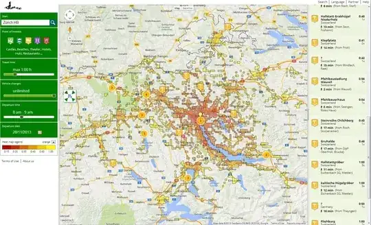
When traveling, I'm often interested in visiting the surrounding area. Unfortunately, map distance doesn't necessarily relate well to travel time, especially when considering public transport.

There is a question specifically asking about travel from Oxford or Cambridge, but that's not were I'm usually staying. Are there any more generic solutions, particularly for central Europe?

Jonas
  • 7,012
  • 40
  • 54

1 Answers1

8

There is, as of now, no general solution for any places, particularly since public transport data is not always freely available, which makes coding such an application difficult.

For places where public transport data is available, there are sites that let you do draw areas of what you can visit.

Mapnificent has a decent number of cities from all over the world. Note that it may not have access to the complete public transport data (see e.g. @Gagravarr's comment).

enter image description here

arrlee works for Germany, Switzerland, and Austria only, and is able to provide overlays of points of interest. It "knows" all public transport stops in these countries, as far as I can tell, and is thus quite reliable.

enter image description here

Jonas
  • 7,012
  • 40
  • 54