I was intending to go to a conference at ExCeL in London Docklands, leaving via London City airport. It seems a very walkable distance between the two, but from Google Maps I can't see if it is practical. Many airports disallow or strongly discourage walking. Will I have to get a taxi, or fiddle around with two DLRs (Docklands Light Rail) (if it's running)? And if I can walk, what route should I take?
Asked
Active
Viewed 1.2k times
5 Answers
24
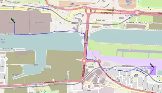
Be careful about trusting the Google Maps walking route, as it wants to send you over Connaught Bridge, which doesn't have pedestrian footpaths! If you use streetview, you can see the lack of footpaths, but also a handy bridge that Google neglects to show...
Instead I'd suggest using OpenRouteService to plan the route, which uses OpenStreetMap data which does include the bridge. That suggests a sub-2km, 20 minute walk,along the dock side, and over the pedestrian bridge:
Updated September 2021:
This route has now been greatly improved by Newham Council with a much nicer, wider asphalt path and lighting. It is now very easy to walk from Excel to LCY via this route and its very quick.
10
The two DLRs are typically very quick and easy - I have walked it, but in the winter, or at night you wouldn't want to.
Just get on a DLR to Canning Town, and the next one out to the airport shouldn't be more than 10 or 15 minutes later
Rory Alsop
- 12,266
- 3
- 53
- 88
6
The postcode for the ExCeL center is, funnily enough, E16 1XL (perhaps where it gets its name).
Plugging that into the Journey Planner, gives you a 32 min walk.
Google Maps suggests a slightly different route, taking 47 minutes.
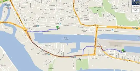
So yes, it's walkable :) I'd take the longer Google Maps one, personally, as you get to see more of the Docklands.
Mark Mayo
- 160,001
- 106
- 687
- 1,492
6
I also was intending to go to the dev days, and bought the plane ticket and two nights at Premier Inn as a consequence.
Fortunately, CodeKen2011 filled that hole, and I wondered the same as you - looking at the map it wasn't completely clear whether I could walk it, and Google maps disclaimer didn't reassure me.
As Gagravarr points out in a comment on Joel's answer, there is a foot bridge which goes underneath the road bridge. It is actually quite pretty down there.
Benjol
- 738
- 5
- 13
4
I do remember walking from a nearby overland train station to City Airport several years ago. But East London is rapidly changing these days, so I can not say whether it is still possible today.
Peter Hahndorf
- 24,915
- 9
- 95
- 155