For a good starting point, Ordnance Survey maps are normally a good bet, although they do not claim to be authoritative on rights of way. You can view the good quality OS maps using Bing maps (although only the desktop web browser version, last I checked app and mobile browser versions did not offer this), or by buying them/subscribing to an alternative service, including from OS themselves.
There is a website claiming to offer fairly comprehensive data on rights of way, based off OS mapping and openly available local authority data: http://www.rowmaps.com/.
If you look at this map provided on rowmaps, you can see that most of the non-road routes from Inglesbatch are marked as footpaths, however the route from Inglesbatch to Englishcombe is a Byway Open to All Traffic, making it a legal route for motor vehicles, as is the route from Inglesbatch to Priston Mill (note: not Priston).
Here is how it looks on OpenStreetMap with added ROWMap data (CC-BY-SA):
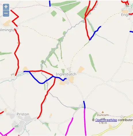
Red lines are Footpaths, Blue are BOATs, Fuscia are Bridleways.
Quick guide to England and Wales rights of way:
- Footpath - right of way for pedestrians only
- Bridleway - right of way for pedestrians, horse riders and non-motorized cycles (for a given value of non-motorized)
- Restricted Byway - any non-motorized form of transportation (again, for given values of non-motorized)
- Byway open to all traffic - For any kind of transport - although note that behaviour on these tracks and paths may be very different to on the roads.
Source for the above
Note that being a right of way for motor vehicles does not necessarily imply that the path/track is suitable for most motor vehicles.
