Is there a convenient way to calculate the cost of tolls between two arbitrary points within the United States? I'm planning to take a trip along the Eastern seaboard and will be passing through multiple states with different toll-collecting authorities. The mapping and trip planning resources I've found so far will only indicate whether a particular section of road has tolls, not the price of those tolls. I'm aware that the various toll-collecting authorities post their rates online, but these charts are often difficult to use if you're not already familiar with the area. Isn't there an easier way?
Asked
Active
Viewed 1e+01k times
4 Answers
16
If you know your route, you could use Tollsmart.com (paywall, $2 minimum) or their free mobile app:
Sample:
CALIFORNIA
17-Mile Drive Toll: $9.25 Location: Scenic drive through Pebble Beach, CA Operator: Pebble Beach Corporation
Golden Gate Bridge Toll: $6.00 (Southbound ONLY) Location: Spans San Francisco Bay connecting San Francisco to Marin County, CA Operator: Golden Gate Bridge, Highway & Transportation District
Riverside Freeway (SR-91) Toll: Variable Location: An east-west freeway in Southern California linking Orange and Riverside counties Operator: Orange County Transportation Authority (OCTA)
Eastern Transportation Corridor Toll: $3.50 (East Branch) $3.25 (West Branch) Location: Orange County, CA Operator: Foothill/Eastern Transportation Corridor Agency
South Bay Expressway Toll: Variable Location: Beginning at Otay Mesa, provides access to/from Mexico and across San Diego Operator: South Bay Expressway, L.P.
The Antioch Bridge Toll: $5.00 (Northbound ONLY) Location: Spans the San Joaquin River linking Antioch, CA with Sacramento County, CA Operator: Bay Area Toll Authority Metropolitan Transportation Commission
The Benicia-Martinez Bridge Toll: $5.00 (Northbound ONLY) Location: Spans the Carquinez Strait linking Benicia, CA to Martinez, CA Operator: Bay Area Toll Authority Metropolitan Transportation Commission
you get the idea.
5
Actually there is a cool app "TollGuru" that can tell you toll cost for all possible routes in United States. It calculates cheapest, fastest and other route options based on total cost (gas and toll cost) and time of your drive based on current traffic. And best part is that you can customize it for your vehicle. It covers all toll roads and bridges in United States.
Sara Smith
- 51
- 1
- 1


2
The Google Maps app (free) shows the estimated toll price for most routes:
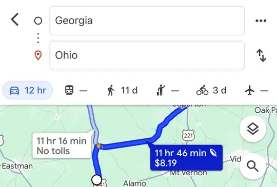
It will sometimes just say "tolls", but I've found that breaking up the route will help you see the actual cost (e.g., Seattle, WA to Billings, MT — no tolls; Billings to Ohio — $6.61).
Laurel
- 213
- 2
- 7